Service
HYDROLOGIC INVESTIGATIONS
We deliver advanced hydrologic and environmental monitoring solutions across the U.S., specializing in Acoustic Doppler Current Profiling (ADCP), reservoir capacity mapping, and sediment transport monitoring.
Acoustic Doppler Current Profiling
MSG’s scientists use industry proven instruments and software to conduct Acoustic Doppler Current Profiling (ADCP) in rivers, harbors, canals, estuaries, and marine environments.
While navigating its vessel along designated transects, MSG collects thousands of flow velocity-direction measurements with its ADCP to develop a database of in situ hydrologic conditions.
MSG uses its onboard RTK-GPS survey equipment to accurately assign a geo-spatial position to each of the thousands of ADCP measurements. The vertical position of each of the measurements is accurately determined by the ADCP.
ADCP data are compiled and analyzed to establish maximums, minimums, and variation, and are correlated with weather events, seasons, point sources, biological productivity, plumes, and other environmental factors. The ADCP data are compiled as histograms, velocity contours, and more.
ADCP data enables a compelling understanding of how varying flows effect the movement of sediments, suspended solids, erosion, deposition, habitat and other environmental conditions.
MSG provides these services nationwide and throughout the US territories.
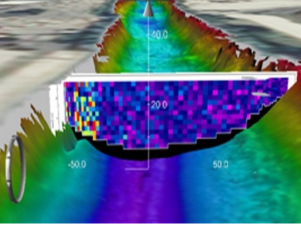
Reservoir Capacity Mapping & Calculation
Significant quantities of sediments that may have accumulated in a reservoir can reduce its water storage capacity. We use advanced survey-grade hydrographic sonars and RTK-GPS survey instruments to accurately map reservoirs and calculate storage capacity.
MSG can also utilize its sub-bottom profiling services to accurately measure accumulated sediments.
SEDIMENT TRANSPORT MONITORING
Specializing in environmental research, mapping, and technology, MSG’s experienced staff uses proven methods and equipment to monitor the movement of sediments within marine, estuarine, and aquatic environments. The accurate monitoring of sediment deposition, erosion, and transport is often a critical aspect for effective management of environmental resources.
MSG uses an array of services sediment transport monitoring to include:
- Bathymetric Mapping
- Benthic Grab Sampling
- RTK-GPS Survey Equipment
- Sediment Traps
- Side-Scan Sonar Surveys
- Substrate Characterization
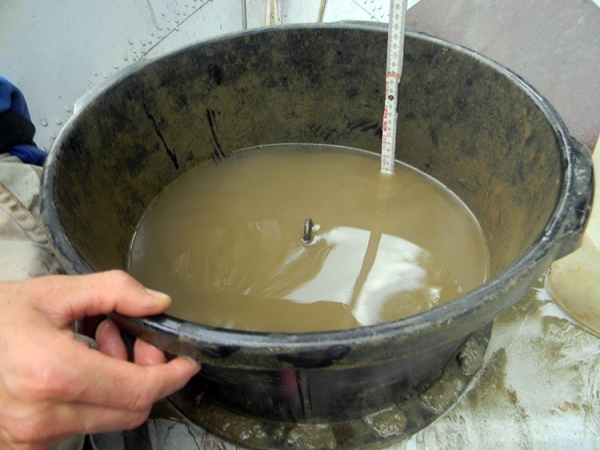
- Suspended Sediment Sampling
- Topographic Mapping